The planned walking schedule through the Lake District

Tuesday 6th September
After all the detailed planning and with excitement building (well, as much excitement as a 69 year old can muster) Mary and I set off on a sunny morning's chauffeur-driven (well, it was a mate who drove us) journey to Pisa airport. Surprisingly all the tolls were unmanned and barriers up on the autostrada, 'that's a nice touch', I thought. Not many people at the airport, 'unusual', I thought. Answers to this cheerful start were soon apparent. Every line on the Departures and Arrivals boards showed CANCELLED! A one day General Strike had been called by the public sector workers' unions, and we hadn't heard a thing about it. As there were only two flights per week to Manchester, and the second one was on Saturday, the day after I was due to start my c2c, the whole of the walk was at risk, not to mention all the money laid out in advance for rail fares, accommodation and baggage transfer! Then a glimmer of hope appeared, the Arrival's board showed the Jet2.com flight due in, and even better, the Departure board showed Jet2.com's flight to Manchester (ours) due to leave on time and for passengers to go to check-in. Our flight was the only one to take off from Pisa that day, the remaining 30 flights remained cancelled - we didn't know why, and we were not asking, just get us out of here! Thank you Jet2.com. http://www.jet2.com/
The rest of the journey went more or less as per schedule, arriving at St. Bees railway station as dusk was gathering and a fresh strong wind, also known as 'Hurricane Katia', that was to be our companion for the next week, starting to gust off the Irish Sea. Why on earth I thought there might be taxis waiting at such a small railway halt, I can't imagine. Not in the plan! Faced with a walk of a mile or so to our guest house - 'what's that compared to the 192 miles you are about to walk', I can hear you say, we had a lot of baggage is my answer - anyway, I looked around for possible means of transport. Wandering into a little bistro (as you do in St. Bees) adjoining the opposite railway platform, we were warmly welcomed by the 'front of house' lady who offered to phone for a taxi. But first we must have a drink, we said. Then we became enticed by the menu, we must eat we said. A quick call to Irene at the Tomlin Guest House to let her know that we would be late and then we were able to relax. Realising we had not had a decent meal all day we decided to tuck in to a Thai Curry - delicious, and some truly delicious desserts. So we highly recommend Lulu's Bistro http://www.lulusbistro.co.uk/ at St. Bees station. We had an added bonus, the chef told us not to worry about a taxi, she would take us, now that is what I call service. After a warm welcome from Irene and David at Tomlin Guest House we were ready for some sleep - it had been a long day.
Wednesday 7th September
You are in England, by the sea, so what do you have for breakfast? It has to be kippers! And Irene does a mean plateful of kippers - the porridge was good as well! Well fed, we ambled around St. Bees http://www.stbees.org.uk/index.htm to see what this little outpost on the north-west coast of England had to offer, apart from the start of Wainwright's Coast to Coast. The public school established over 400 years ago is one the oldest in England.

St Bees Public School founded in 1583
Not far from the school is the Priory Church of St. Mary and St. Bega the foundations of which were laid in over 1,000 years ago, also built in the local red stone.

Priory Church of St. Mary and St. Bega

The Priory Church, in the nave looking towards the chancel
Having done the history 'thing', we decided to blow the cobwebs away and have a look at the clifftop walk which forms the start of the c2c. Looking at the coast line in one direction, it looks quite benign, rolling green hills.

Looking north towards St. Bees Head and the Coast to Coast Path
.Looking the other way, decidedly rougher!

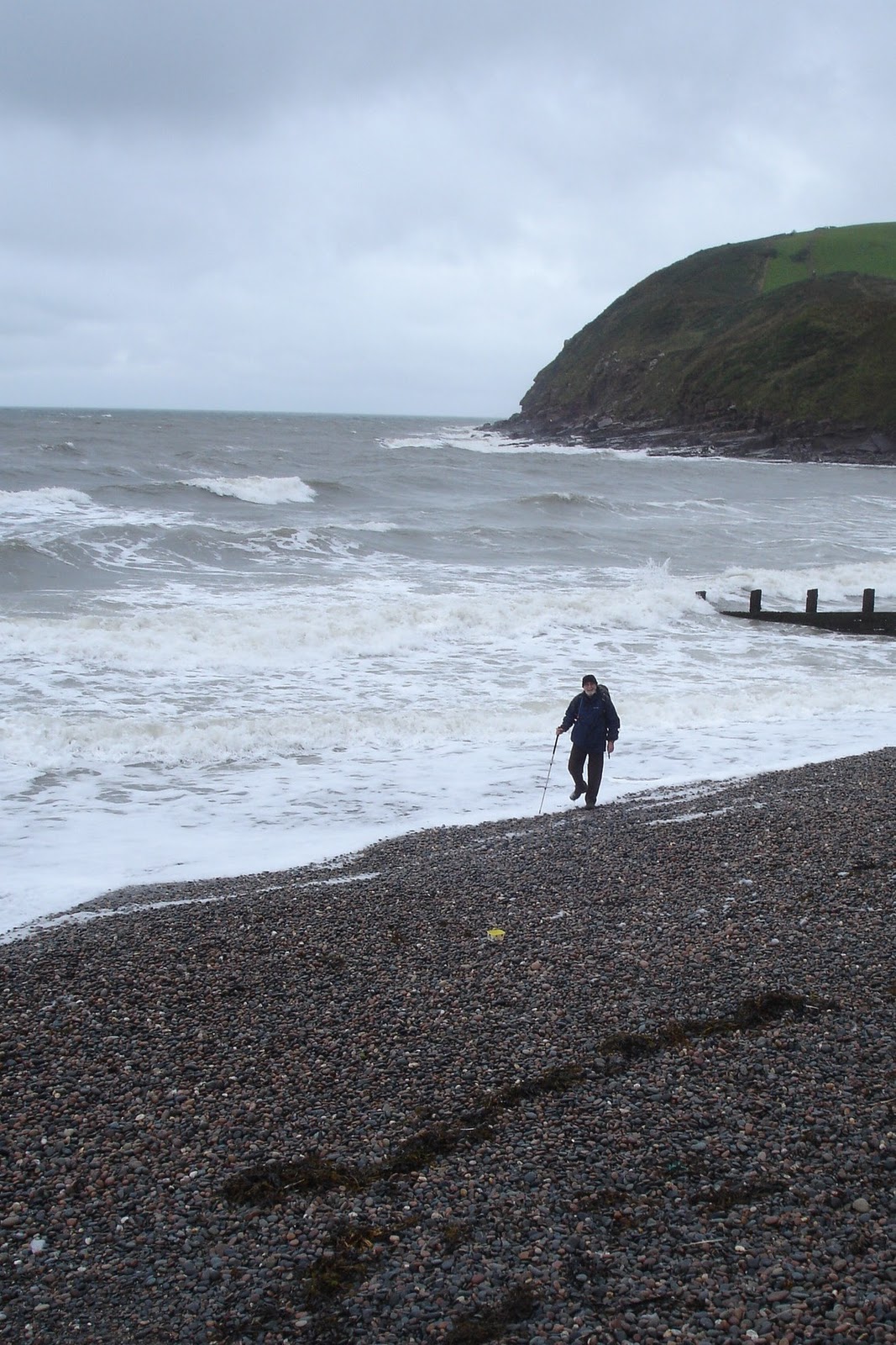
Plenty of pebbles waiting for c2c walkers to transport to Robin Hood's Bay
The walk up on to St Bees Head was far from benign, Katia was building up and threatened to have us over the cliff edge a couple of times. But at least we stretched our legs (and lungs) and it was good preparation for what was to come. All that fresh air meant that a good meal was needed that evening, so Lulu's Bistro it was, again - we reasoned that over the coming fortnight most of our eating was going to be 'pub grub' and Lulu's is a couple of notches above that.
Thursday 8th September - St. Bees to Sandwith
Our original plan had been to arrive in St. Bees, have one day, Thursday, adjusting to UK weather etc., and then start the walk. But, having booked all the accommodation at the end of 2010, we found that the new flight schedules, when they were published in March 2011, pushed us into spending two full days in St. Bees. Not to waste an opportunity, we took advantage of Wainwright's eccentric plan to go west, then north before heading east towards Robin Hood's Bay. Basically, it meant that it was possible to do the first five miles of the walk to the village of Sandwith, with just a short amble back to St. Bees, less than two miles away. It also gave Mary the opportunity to walk the first part of the walk with me. The cunning plan for the next day, Friday, was to take the bus to Sandwith and, starting from where I finished today, walk to Ennerdale Bridge, thereby splitting my first 'planned section' into two easy parts - easing my way into the c2c. At this stage I should point out that this c2c was planned as a solo walk for me, with Mary being a passenger with the Packhorse, http://www.c2cpackhorse.co.uk/ . Mary would join in on the shorter and flatter (very little climbing) day walks.
Anyway,with a good full English breakfast tucked under my belt, and Mary's usual minimal breakfast tucked under hers, we were ready to face the day. Down on the beach, I wet my boots in the Irish Sea and picked up the traditional pebble to transport to Robin Hood's Bay - the journey begins!

Plaque on St. Bees promenade
Dipping my boots in the Irish Sea

c2c signpost pointing the way - up the gravel steps.
(The footpath to the stile in the background is the one used back from Sandwith)
We left the beach at 10.30am, ahead we could see groups of 2s, 5 and individual c2cers striding out towards the clifftop on their way to Ennerdale. We ambled, as we were not in a rush, we wanted to make the most of the views and consequently were overtaken by more walkers on their way to t'other side of the country. One of the groups, who we were to meet many times on the days ahead, consisted of seven Americans aged between 50 and 80!! All were very fit and very cheerful.

St Bees North Head and Fleswick Bay with a bit of dampness coming in!!

Mary heading up St. Bees North Head - ' I thought I was only doing the flat bits!!'
Once on the top, but keeping back from the cliff edge we headed north, past the Lighthouse, to an old quarry where the Coast to Coast path finally heads east towards Robin Hood's Bay, and Sandwith where the American party were enjoying their lunch, and a rest on the village green. We reached the Dog and Partridge pub at the top end of Sandwith at 1.30 pm - it was closed! So we sat outside and ate our sarnies.
Day's distance 7.88km ( a smidgin short of 5miles).
c2c cumulative distance - 7.88km - 5 miles
Then the sun came out! So we headed back down a country lane and across a couple of fields for a welcome cuppa and cake at the cafe on the sea front at St. Bees. (3.3km but not counted in the overall c2c distance).c2c cumulative distance - 7.88km - 5 miles

Mary climbing over a stile in style! (note also, the blue sky)
Friday 9th September - Sandwith to Ennerdale Bridge
At last the day dawned on the date that had been etched in my mind for nigh on 12 months - the 'official' start to my Coast to Coast. At breakfast we met three walkers who, later, were going to be good company at different stages across the Coast to Coast, Kevin and Paul from London and Kevin from Melbourne, Australia. Kevin from Oz had arrived in England on Thursday morning, made his way straight up to St. Bees and was all set for the off with a 20kg rucksack on his back! Imagine carrying that weight for 192 miles! He had planned to do some camping rather than B&B on the way so he was carrying everything. Again, another good breakfast inside me and again, another wet morning as I said my farewell to our hosts, David and Irene, until my next c2c! And, farewell to Mary until the afternoon in Ennerdale Bridge. The other three guys had set off some time before me at 8.30, I would reach Sandwith first but hoped they would catch up with me by the time I reached the top of Dent.
The 10 o'clock bus from St Bees dropped me off at the Dog and Partridge (still closed) in Sandwith at 10.25 and by 10.30 I was on my way. There was a certain feeling as I put my first foot forward, despite yesterday's joint effort of 5miles. This was somehow different, here I was at the age of 69 years (and 347days) setting off on what could be a solo walk across England - if I was unlucky and didn't meet up with anyone, which was highly unlikely given the numbers that we had seen setting off on previous days. I think the word that describes what was going through me at the time was a frisson - an emotional thrill (silly old fool). Anyway, getting back to putting the first foot forward, it went straight into a puddle. Although it wasn't raining, there was a mist in the air as I approached the railway line near Stanley ponds and the paths across the ground beyond were sodden. After much splodging around I decided to take an alternative track on to higher ground which brought me out on to the Cleator Moor to St. Bees road, just south of the turning for Moor Row.
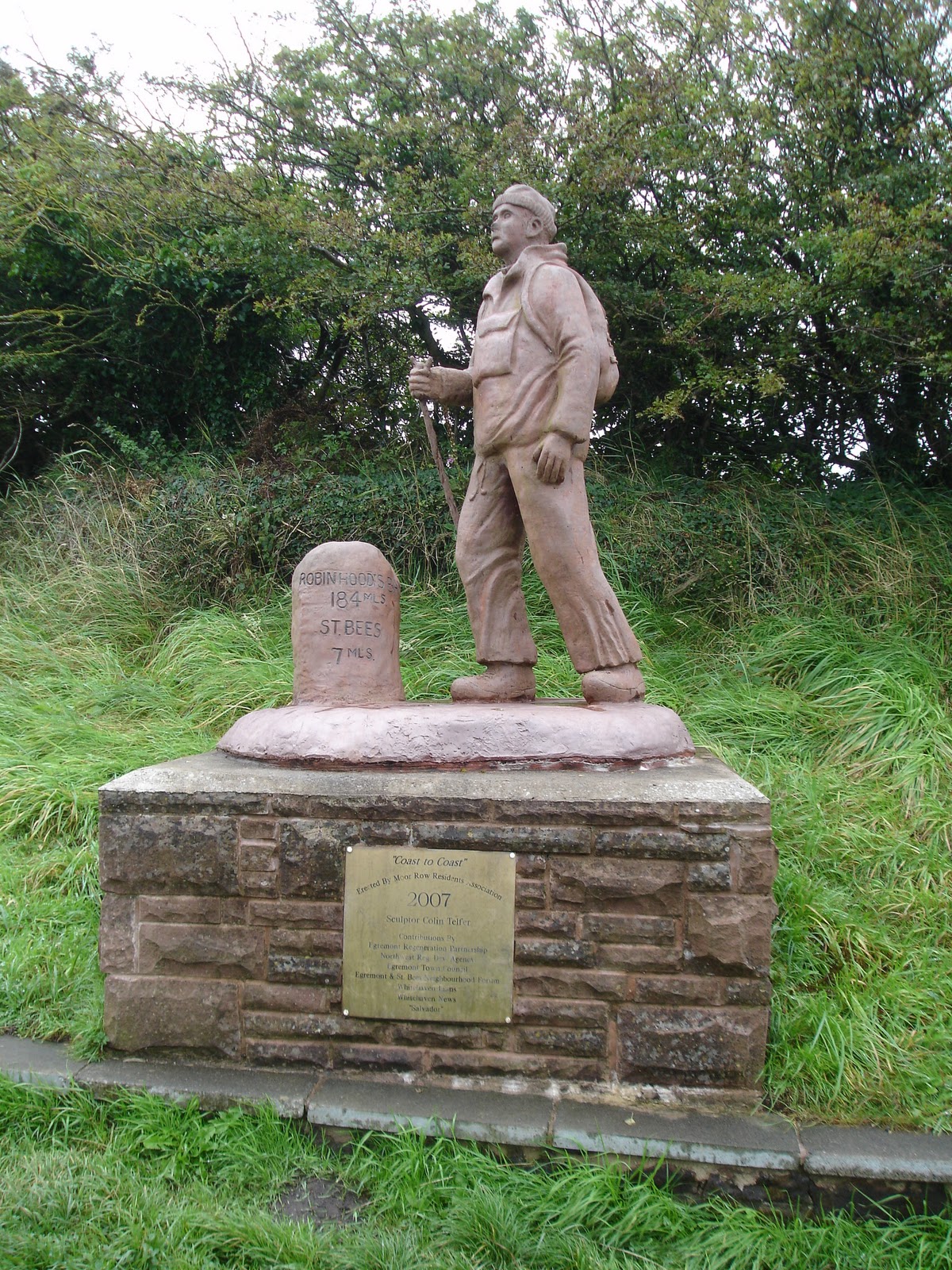
Moor Row, sculpture of Coast to Coast walker by Colin Telfer
Just further up the road from Telfer's sculpture I picked up the disused railway line, now a National Cycle Trail, that took me around Moor Row and into Cleator. Passing Blackhow Farm just beyond Cleator, with the mist coming down, I started the climb through Blackhow plantation to a stile leading on to Dent. By now it was nearly 12.30 so a nearby bench provided a suitable resting place to have lunch. Getting to the top of Dent was going to be easy, just follow the line of the stone wall, but I knew that with the mist thickening I needed to get to the top as soon as possible so that I could take a bearing, which fortunately I managed to do before visibility was reduced to almost zero.

Approaching the cairn at the top of Dent (353m)
The track across Dent had become almost non-existent, just a wide morass of mud, water, sheep-droppings and ground-hugging vegetation. It was a bit daunting but I continued on the same bearing until I spotted the two water tanks on the right, as mentioned by Wainwright. The mist was starting to lift and then, just ahead, was the track and half-left I could see the tall stile, across which I could access the ridge down to Nannycatch Gill.

Looking back up to Dent - note the tall stile in the fence-line

Looking across Nannycatch Gill
Across the stile, as the mist was lifting, the gold-coloured grass was catching the brighter light as the sun tried to pierce the gloom. An excellent looking hill descent changed into a nightmare as the angle steepened, the wide swathe of short-grazed grass cutting through the bracken was soaking wet from the mist and rain, and had turned into the equivalent of a ski-slope. I tried to zig-zag across the grass but the inevitable happened. One minute I was watching my step, the next, with arms and legs all over the place, I was up in the air looking at the sky, then thumping down onto the ground and sliding graciously down the hill for a few metres. I thought 'I am sure the people in the farmhouse opposite sit at the window on days like this waiting for idiots like me!' The rest of the short descent was precarious, trying to avoid short grass and muddy sections which were just as slick. I am sure on a fine day it is a very pleasant stroll down the hill - but not today!

Nannycatch Gill on a wet day!
It all became worthwhile when walking through Nannycatch Gill listening to the stream resonating musically in the damp silence of the valley. Out of the valley and closing in on Ennerdale Bridge, there is a pleasant footpath separated from the road by a small hedge - which is fortunate as the road is used as a 'rat-run' by the hundreds of people in West Cumbria employed at Sellafield nuclear re-processing site on the coast. It was good to see Ennerdale and the Lakeland Fells not too far away.

First view of the Lakeland Fells
Mary was waiting at the end of the road at the junction with the lane into Ennerdale Bridge. We arrived at the Shepherds Arms at 3.00pm - four and half hours in total, not bad for a first day. Strangely I did not see a single walker all day.
Day's distance - 16.15km - 10.05 miles
c2c cumulative distance - 24.03km - 15.05 miles
Note: All the distances quoted in this blog are as per my GPS Foretrex device in kms. The conversion to miles are my own calculations (ie km x 5/8 = miles), and are therefore approximate.
Saturday 10th September - Ennerdale Bridge to Stonethwaite
This day turned out to be 'Wet, Wet, Wet, Windy'.
After a comfortable night's sleep at the Shepherd's Arms and a good breakfast we met up with my daughter Rachel and her family, husband Ashley and children Jack, Hannah and Issie. They had got up at the crack of dawn, driven over from Tyneside and were ready to go before I had finished my breakfast. And were ready not only to walk 27km (17miles) but also to drive back home at the end of the day - what it is to be young!!

All ready to go!
We said our farewells to Mary at 9.30am, then strode off in the direction of Ennerdale Water where we were met by a fierce spray being whipped up off the lake. I had already decided to take the path along the north-side of the lake rather than the 'official' route around Angler's Crag - regarding the stony track as being too hard on my feet, and also, in the day's conditions, being too slippery underfoot. I think it was wise and interesting choice, the pathway twisted and wound through undergrowth and bushes which gave Ashley plenty of excuse for foraging for wild fruits.

Ennerdale Water - we walked around the left-hand (north) side

Ashley leading the family foraging

Definitely not for picking!
Emerging from the 'undergrowth', we picked up the the dirt road from Ennerdale Bridge to Gillerthwaite and headed on past the Youth Hostel to the point where a track heads up to Red Pike. A decision had to be made, do we go up to Red Pike then along the ridge trail towards Haystacks? Or, along the valley? But first we decided to eat, although it wasn't quite noon, a snack was in order. I had some 'sarnies' but they were not needed. When Rachel emptied her rucksack she could have fed the proverbial 5000! So, fueled with cake and other goodies we were ready to go. The weather was worsening and the decision was made that it was too dangerous to consider take the Red Pike route. So along the valley we went, some attempting to fly!

Hannah, Issie and Jack attempting take off in the strong wind
By the time we had reached Black Sail Youth Hostel, there were quite a few c2c-ers gathered having a break. They were going to take the traditional Loft Beck route, however, we decided, as the weather had started to improve a little, we would back-track a couple of hundred metres and go up the Scarth Gap trail so that we could go over Haystacks. The wind was still very strong but the rain had stopped.
Going up Scarth Gap was like walking up a stream, so much water running about, but it was easy going so long as you didn't slip. On reaching the top of Scarth Gap we savoured the excellent views over Buttermere before turning to scramble up Haystacks.

Track up Scarth Gap

Scarth Gap

Buttermere

The children went up here like mountain goats!

Now it's my turn to go up - like a silly old goat!
With gusts up to 60mph (we heard later) we made it to the top, despite a lot of buffeting from the wind.

Made it! Just having a breather (well Grandad was anyway)

On our way down from Haystacks

Innominate Tarn
From Innominate Tarn we headed for Blackhowe Tarn, the whole of the landscape was stark with sharp outlines in the stormy light.

It's downhill all the way now!
We then headed for the direct route to Dubs Quarry, but by now it had started raining as we wound our way up out of the hollow around the tarn. Fortunately, there was no mist so we could see quite clearly where we were going. From the top we could see a bowl filled with a sweep of gold and green grasses. Beautiful but full of hidden problems as were to find out. One problem was keeping our feet on the ground. I took my eye off where I was walking, next minute I was sliding to the left with my arms and legs all over the place, then to the right in similar angular poses, then almost going flat on my face before finally regaining my balance. I am sure the children thought that Grandad had finally 'lost it'! The whole of the area was squelchy, without being boggy (it wasn't deep mud), but as we approached what should have been a narrow stream, we could see it it was a torrent about three metres wide. Ashley went off to find a narrower crossing to no avail, so it was time to get our feet wet!

Water, water everywhere!

Squelchy and very wet!
Once across the stream we climbed out of the 'wet area' up to Dubs Quarry. To our right we could see a line of about fifteen walkers coming along the trail from the direction of Loft Beck. We took the direct route down the old tramway to the the Honister Slate Quarry offices and cafe.

Hope the cafe is still open!
We arrived just as the cafe was closing but the staff still had time to make us all a cup of tea, it was very much appreciated. Thank you to the staff. We were stood having our cuppa, wondering why there was an ambulance nearby when suddenly we heard a thud,thud and a helicopter appeared, as if from nowhere , and landed in the car park. It was a Search and Rescue party. It had come to pick up a cyclist who had quite a serious off-road accident.

Honister Pass, from the Honister Slate Mine
The party of Americans, if you have been pay attention you will recall Mary and I meeting them on Thursday in Sandwith, were just getting on the bus to take them to Rosthwaite as we set off for an hour's walk into Stonethwaite. We arrived in Stonethwaite at 6.30pm, nine hours after we left Ennerdale Bridge - the walking time was 7hours. Quite an effort for me but more so for the three children, especially as they had been up since the crack of dawn. Well done Jack, Hannah and Issie - and Rachel and Ashley! Mary was waiting for us, I think getting a bit worried, especially as she couldn't contact us due to lack of mobile signal - a problem we were to encounter over the entire length of the walk. Also there were my other daughter Sarah, husband Tim and daughter Eliza - they were camping overnight and then doing Sunday's walk with me.
But first we had to eat! Fortunately we had booked a table in advance at the Langstrath Country Inn, http://www.thelangstrath.com/ , which was just across the road from our accommodation, Knotts View, so while Tim drove Ashley back to Ennerdale Bridge for his car, I got into some drier clothes and then went and sank a few beers (Jennings Cocker Hoop, just to mention one of them) in the bar! The meal (and the service) in the Langstrath was excellent. As wandered back to our B&B Rachel and family set off on their 2 hour drive back to Tyneside, while Sarah, Tim and Eliza headed to their camp site!!
Day's distance - 27.3km - 17.06 miles
c2c cumulative distance - 51.33km - 32.11 miles


 Taking a breather


Sunday 11th September - Stonethwaite to Grasmere
This was already another wild and wet day before we even started! Fortunately we had had a good night's sleep at Knott View, our highly recommended B&B in Stonethwaite, and with a substantial breakfast inside me I was ready to face the day. Sarah, Tim and Eliza seemed none the worse for having camped and were ready to go, the car packed ready for pick up later.
We set off at 10.15am on a long steady climb up towards Greenup Edge in wet blustery conditions.

At least we had a track we could follow at this point!
There were waterfalls everywhere - on the hillsides around us, on the paths under our feet, and in our boots. As we climbed higher the obvious tracks were, in places, now not only under water but the water was spread wide - miss the path and you could find yourself in boggy black stuff! Eliza seemed to take great delight in finding the 'boggy black stuff' and I soon learned not to follow her!
 |
| Looking back down towards Stonethwaite |
 |
| ... and looking forward, up to Greenup Edge |


... onward and upward

Still some way to go - note the walkers ahead(with white covers on their rucksacks)
As we reached the top of Greenup Edge decisions had to be made, whether to follow the classic route over Calf Crag, or the more direct alternative route down Far Easedale. But, once more the mist was starting to cover the Calf Crag, and the rain was starting to get heavier - so the direct route it was. With yet more streams to be splodged through we were past caring how wet our feet were.

Splodging!
As we started our descent everywhere was a wonder-world of waterfalls cascading over clifftops. Ghylls normally running with tranquil tumbling streams had been turned into tumultuous torrents. As we were completing our first 8km (5miles), Tim, in complete walking gear, dived behind a huge boulder and emerged (a la Superman) minutes later in his running gear ready to run back to Stonethwaite to pick up the car and meet us in Grasmere.! Fortunately he is a fell runner!
We had to press on, especially as Eliza hoped we would be in Grasmere before the Gingerbread Shop closed. www.grasmeregingerbread.co.uk As we arrived at the edge of the village Sarah and Eliza continued into Grasmere to find somewhere warm and to get a hot drink inside them, meanwhile I headed 2 miles north to Townhead Farm, arriving there about 16.15. www.townheadfarmbedandbreakfast.co.uk Six hours to walk 13.4km (8.5miles) shows the effect the weather on our walking progress. Mary had arrived much earlier with Packhorse, so all I had to do was shower and change, then figure how were going to get back into Grasmere to meet up with Sarah, Tim and Eliza. Fortunately, Jackie, the B&B landlady offered to run us into the village - a wonderful gesture. Once in Grasmere, we had a look around for Sarah, and ended up in the Gingerbread Shop stocking up with sustenance for my walking days ahead. We eventually found Sarah, Eliza, and Tim, hidden behind big mugs of tea and slices of cake in a very welcoming Baldry's Tea-rooms - joining in seemed like a good idea for afternoon tea on a dank day. http://www.facebook.com/pages/Baldrys-Tea-Room/267282139778
It had taken Tim less than an hour and a half to get back to the car and drive to Grasmere!!
The evening meal was at the Lamb Inn where the Steak and Ale Pie is highly recommended, Later, Sarah and family took us back to Townhead farm before continuing on their journey home to West Yorkshire. Thanks Sarah, Tim and Eliza, I think the day would have been quite a struggle without you!
Day's distance - 13.4km - 8.37 miles
c2c cumulative distance - 64.73km - 40.48 miles
Monday 12th September - Grasmere, Townhead Farm to Patterdale
The wind had been howling around Townhead Farm all night, and with rain lashing at the window panes we prepared ourselves for the day with some trepidation - fearing what the day may bring and whether I would be able to go out that day. However, with another good full English breakfast inside me, and after chatting to Donald, the farmer, I felt ready to face the day. Donald had been up on the hills since 6.00am tending his sheep and, whilst it had been raining very heavily with very strong winds, visibility was good. Also, I knew the trail today was a well defined track and that there could be up to 25 other walkers setting out from the Grasmere area to do the walk to Patterdale - so shouldn't be short of company today! As my B&B was closer to Mill Bridge, where the c2c path heads up to Great Tongue and Grisedale, than the village of Grasmere, there was a good chance I would soon meet up with other walkers. So, by 10.15 (I don't like to be rushed on a morning - too much of that during my working life) I was all togged up in my wet weather gear once more - looking for blue patches in dark rain-laden overcast skies.
The wind had been howling around Townhead Farm all night, and with rain lashing at the window panes we prepared ourselves for the day with some trepidation - fearing what the day may bring and whether I would be able to go out that day. However, with another good full English breakfast inside me, and after chatting to Donald, the farmer, I felt ready to face the day. Donald had been up on the hills since 6.00am tending his sheep and, whilst it had been raining very heavily with very strong winds, visibility was good. Also, I knew the trail today was a well defined track and that there could be up to 25 other walkers setting out from the Grasmere area to do the walk to Patterdale - so shouldn't be short of company today! As my B&B was closer to Mill Bridge, where the c2c path heads up to Great Tongue and Grisedale, than the village of Grasmere, there was a good chance I would soon meet up with other walkers. So, by 10.15 (I don't like to be rushed on a morning - too much of that during my working life) I was all togged up in my wet weather gear once more - looking for blue patches in dark rain-laden overcast skies.
 |
| All ready to splash out! |
 |
| ..on my way - is that a bit of blue in the sky? |
I was soon at Mill Bridge and started my long ascent up the eastern side of Little Tongue. Progress was good despite the difficulties caused by strong buffeting winds. After a while I glanced back and could see two young American ladies, who I had met previously, crossing the road at Mill Bridge. Ahead of me I could see about 15 walkers climbing slowly upwards, and a short distance behind them there was another group of 5 walkers - must be rush hour!
Once clear of the shelter afforded by Little Tongue and Great Tongue exposure to the elements became apparent, especially when the track twisted and turned around the rocks. The change in the body profile as one turned left or right meant the wind hit a large cross-section (because of our packs) side-on and it was easy to be thrust off balance. At 11.30am I took a breather to photograph the view back towards Grasmere.
 |
| Looking back towards Grasmere |
After another half hour, having passed the large group of Americans, I caught up with Kevin and Paul (I first met at St Bees B&B) just as we reached our first view of Grisedale Tarn.
 |
| All wrapped up for Grasmere Tarn |
The wind was so strong it was whipping up spray across the water that was so dense at times it was difficult to see across the Tarn. When we reached Grisedale Beck, the outlet from the Tarn, it was a raging torrent about 5 metres wide, and obviously another boot-filling crossing. A group had already crossed and were shouting advice to us. The only safe way to cross was to link arms and march through the water forcefully, trying to ignore the spray from the tarn as it hit our faces like ice-bullets. We made it across OK but the following group of about 15 people, including the previously mentioned American party, struggled - one or two had to be carried over. The following video attempts to show the struggle to get them across - it also shows the struggle to stand upright and attempt to hold the camera steady in winds which were now reaching 70mph (110km/hr). We owe a great many thanks to Steve, an experienced hill-walker who was acting as trail guide and leader to a group of c2c-ers.
By now the wind speed was in excess of 70mph (110kmph), this was confirmed later, making the descent into Grisedale perilous as we negotiated the twists and turns in the trail. I was caught in one sudden change in wind-speed and direction and flung to the ground. The force with which I hit the rocky ground was sufficient to shear the metal bracket on my wrist GPS - at least I didn't break my wrist!! On getting up and regaining my balance Steve, the trail guide, insisted that a group of us linked arms and take a straight line through the grass and heather to avoid changing direction. So he, one of his party, Louise, Paul (from Hull) and myself linked arms and marched across all the corners and bends in the trail - it was still difficult to stay upright in the strong winds but we made it. Again, thanks Steve.


After this stretch, it still took me over half an hour to descend the mile down to Ruthwaite Lodge. Here I was able to gain some shelter in the lee of the building to have a bite to eat in some sort of comfort - perched on a rock! But not for long, others were on there way down and needed to have some respite, and space was limited - time to move on.

Walking became easier now on the descent as the lower ground afforded more shelter- almost tranquil in the lower valley. Cows looking at us as if to say 'what's the fuss about?'.

Before going on to our accommodation, I just had to sample some of the Real Ales from the White Lion - excellent! http://www.thewhitelioninnpatterdale.co.uk/

Then we went across the road to the village store to stock up with provisions - muesli bars, Kendal mint cake etc - for the oncoming days' sustenance, before heading for our accommodation at the Old Water View Guest House - http://www.oldwaterview.co.uk/ for a welcome shower and change of clothes.
We highly recommend Old Water View, the owner, Ian, does an incredible job running the guest house to a high standard, making marvelous preserves, bringing up a young family, and providing a warm welcoming greeting on arrival. His walking experience, including the c2c in both directions, enables him to provide sound advice on walking in the area. The accommodation was superb and the breakfast was excellent.
Our evening meal at the White Lion went down a treat, Mary topping hers off with 'noffee ice-cream' (banoffee sauce but without the banana).

All in all, for such a short walk, it had been quite a tiring day, but it was, to repeat a word I used constantly over the c2c, an exhilarating day. I thoroughly enjoyed being out in the elements and having the camaraderie from all the other walkers around that day, made it a day to remember.
Tuesday 13th September - Patterdale to Shap
Hurricane Katia was still at full strength and wreaking havoc around the Lake District with wind speeds of up to 50mph in the valleys and forecast to be in excess of 70 mph on 'the tops'. After a lot of soul searching, I had to agree with Ian, the owner of the Old Water View and an experienced fell walker, that it was not only too risky for me in the high winds and the low cloud, but could also unnecessarily involve the Mountain Rescue if something went wrong. Ian suggested taking the bus to Pooley Bridge, at the northern end of Ulleswater, and walking from there to Shap, the highest point on that route would only be 300 metres. Apparently, this was a route that AW had used in inclement weather. A bonus for me was, because the route required very little climbing, Mary could walk today's section. So, having arrived in Pooley Bridge with a group of other like-minded c2cers at 10.30 am, we did a little bit of shopping in the Outdoor shop and set off walking at 11.00am,
It was a gentle climb up on to Askham Fell with sun trying to break through the blustery conditions.


As we crossed the road near Halton, after leaving Askham Fell, two police cars came hurtling down the road with sirens blaring - it was a road to nowhere!! Two minutes later we heard them coming back (must have taken a wrong turning) by which time we were out of sight heading for Beckfoot. Just north of Bampton we met up with a young couple doing the c2c, we had been referring to them as 'the children' as we didn't know their names until much later, sorry Debbie and Paul (there were a lot of Pauls on this walk), Paul was sat on a wall tending his blisters. We found a comfy spot a bit further down the road outside a big old house and had some lunch - it was nearly 3.00pm.


We arrived at the north end of Shap village about 5.30pm forgetting how long the village was, at least 2km, and our accommodation was the last house at the south end of the village - it seemed a long 2km! But it was worth it. Brookfield House http://www.brookfieldshap.co.uk/ provided a warm welcome from Margaret immediately we arrived at 6.00pm. Our wet gear was hung up, we were shown to our room and then told to be downstairs in 8 minutes for hot fresh made scones and tea. We were down in the guests lounge in 7 minutes, a minute later in came Margaret with a plate of 'fresh from the oven' scones and a big pot of tea - heaven. This is an excellent guest house, Margaret certainly knows how to look after guests.
That evening we ate at the Greyhound Inn, being the nearest pub, and had a good meal of fish and chips (just like Wainwright) washed down with a pint of real ale.
Considering this was Mary's first full day of walking she did remarkably well and it was good to have someone to walk with all day - we both enjoyed the day.

Looking back up towards Grisedale Tarn - Steve, Louis and Paul on their way down

Looking down Grisedale towards Patterdale
A 360 degree view around Grisedale from just below the Tarn
After this stretch, it still took me over half an hour to descend the mile down to Ruthwaite Lodge. Here I was able to gain some shelter in the lee of the building to have a bite to eat in some sort of comfort - perched on a rock! But not for long, others were on there way down and needed to have some respite, and space was limited - time to move on.

Looking from just below Ruthwaite Lodge, down Grisedale with Place Fell in the background
Walking became easier now on the descent as the lower ground afforded more shelter- almost tranquil in the lower valley. Cows looking at us as if to say 'what's the fuss about?'.

Tranquility - 1

Tranquility - 2
I kept to the main track, rather than follow AW's path to Patterdale, to meet Mary at the end of the lane. We arrived in Patterdale at 3.00pm. What an exhilarating day! Five hours to walk 12.4km (7.75miles) - reasonable considering the conditions.Before going on to our accommodation, I just had to sample some of the Real Ales from the White Lion - excellent! http://www.thewhitelioninnpatterdale.co.uk/

Patterdale - Patterdale Village Store on the left and the White Lion on the right
Then we went across the road to the village store to stock up with provisions - muesli bars, Kendal mint cake etc - for the oncoming days' sustenance, before heading for our accommodation at the Old Water View Guest House - http://www.oldwaterview.co.uk/ for a welcome shower and change of clothes.
We highly recommend Old Water View, the owner, Ian, does an incredible job running the guest house to a high standard, making marvelous preserves, bringing up a young family, and providing a warm welcoming greeting on arrival. His walking experience, including the c2c in both directions, enables him to provide sound advice on walking in the area. The accommodation was superb and the breakfast was excellent.
Our evening meal at the White Lion went down a treat, Mary topping hers off with 'noffee ice-cream' (banoffee sauce but without the banana).

All in all, for such a short walk, it had been quite a tiring day, but it was, to repeat a word I used constantly over the c2c, an exhilarating day. I thoroughly enjoyed being out in the elements and having the camaraderie from all the other walkers around that day, made it a day to remember.
Day's distance - 12.40km - 7.75 miles
c2c cumulative distance - 77.13km - 48.23 miles
Tuesday 13th September - Patterdale to Shap
Hurricane Katia was still at full strength and wreaking havoc around the Lake District with wind speeds of up to 50mph in the valleys and forecast to be in excess of 70 mph on 'the tops'. After a lot of soul searching, I had to agree with Ian, the owner of the Old Water View and an experienced fell walker, that it was not only too risky for me in the high winds and the low cloud, but could also unnecessarily involve the Mountain Rescue if something went wrong. Ian suggested taking the bus to Pooley Bridge, at the northern end of Ulleswater, and walking from there to Shap, the highest point on that route would only be 300 metres. Apparently, this was a route that AW had used in inclement weather. A bonus for me was, because the route required very little climbing, Mary could walk today's section. So, having arrived in Pooley Bridge with a group of other like-minded c2cers at 10.30 am, we did a little bit of shopping in the Outdoor shop and set off walking at 11.00am,
It was a gentle climb up on to Askham Fell with sun trying to break through the blustery conditions.

View back to Ulleswater and Watermillock

View towards Hallin Fell and Place Fell

View across Askham Fell

Approaching Bampton
Having built up a thirst we were looking forward to a drink in the pub at Bampton - the door was open but the pub was closed. Then we tried the Post Office across the road which was advertising 'Teas and Cakes' - the Post office was open but the 'Teas and Cakes' was closed! So it was going to have to be water and juice for the rest of the way to Shap. We reached Shap Abbey about 4.30, enough time, and light, to take some photos and and continue onwards to Shap.
Approach to Shap Abbey

Shap Abbey
We arrived at the north end of Shap village about 5.30pm forgetting how long the village was, at least 2km, and our accommodation was the last house at the south end of the village - it seemed a long 2km! But it was worth it. Brookfield House http://www.brookfieldshap.co.uk/ provided a warm welcome from Margaret immediately we arrived at 6.00pm. Our wet gear was hung up, we were shown to our room and then told to be downstairs in 8 minutes for hot fresh made scones and tea. We were down in the guests lounge in 7 minutes, a minute later in came Margaret with a plate of 'fresh from the oven' scones and a big pot of tea - heaven. This is an excellent guest house, Margaret certainly knows how to look after guests.
That evening we ate at the Greyhound Inn, being the nearest pub, and had a good meal of fish and chips (just like Wainwright) washed down with a pint of real ale.
Considering this was Mary's first full day of walking she did remarkably well and it was good to have someone to walk with all day - we both enjoyed the day.
Day's distance - 18.10km - 11.31 miles
c2c cumulative distance - 95.23km - 59.54 miles
The rest of the walk - as it really happened - will be on two separate pages, one covering Shap to Ingleby Arncliffe and the other covering the North Yorkshire Moors.